- Applications
- Health & Fitness
U-Biker: GPS Track
| Install | 1.5 K |
| From 1 Rates | 5 |
| Category | Health & Fitness |
| Size | 27 MB |
| Last Update | 2026 February 20 |
| Install | 1.5 K |
| From 1 Rates | 5 |
| Category | Health & Fitness |
| Size | 27 MB |
| Last Update | 2026 February 20 |
Images


Introduction
The most reliable and sophisticated activity tracker. No account required. No ads.
📈 Science underneath
INNOVATIVE ALGORITHMS – machine learning and robust statistics algorithms are utilized for data processing.
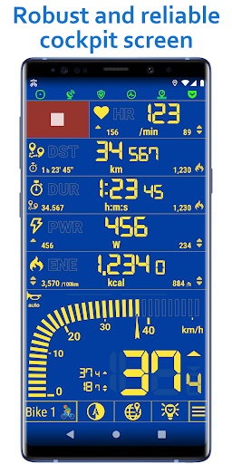
NUMBER CRUNCHING – more than 75 statistics computed for every activity in sub-second resolution, raw data available in CSV format.
PHYSICAL CONSISTENCY – maximum speed cannot possibly be smaller than average speed, and metrics shouldn't spike without a cause.
MATHEMATICAL CONSISTENCY – problems of decimal rounding, finite precision, or round-off errors are all handled very carefully for top-notch accuracy.
✅ Ideal for adventures, not just sports
Modern bikers often use more than one means of transport throughout a day. The application can be used to track many of your day-to-day activities, like walking and running, car driving, and even flying.
• GPS & Tracking
🔒 No account required
⏯️ Automatic pause
↩️ Any track can be resumed at any time
🛰️ GPS automatic sleep: Saves battery by turning off GPS when you stop
✨ Adaptive GPS interval: Saves battery by using GPS less often when you're going slow
🏃 Physical activity recognition
🏔️ Barometric altitude (use barometer sensor)
⛰️ Offline altitude (use elevation data from offline maps)
📐 Audio and voice notes: Marks relevant points of your activity, such as every 1 km, every 10 minutes, every 100 m of ascent, etc.
🔥 Energy details: Examine individual contributions (climb, drag, roll, etc.) that make up a total energy spent
⚡ Power with or without a power sensor
🚀 Functional threshold power (FTP) estimate
🚵 AutoTerrain: Senses terrain roughness and adjusts power and energy consumption accordingly
📊 Advanced digital filters of our own design (IIR, FIR, non-linear): Superior accuracy and response
↗️ Works accurately on extremely steep terrain
⚓ Reduce location noise
🛡️ FenceGuard: Hide the location of your home or other important places from the recorded tracks
📟 Bluetooth and ANT+ wireless sensors
📟 Automatic sensor selection
🧭 Compass
🏔️ Inclinometer
🚲 Automatic wheel circumference
⚙️ Gear ratio
🌊 Kinetic energy: Shows you the fall height equivalent to your current speed, so you can better perceive potential danger
🔥 Braking energy: How much energy you lost by braking
👥 Multiple vehicle and activity profiles
🤝 Share to Strava, Google Fit
🌀 App can also be used without GPS, e.g. for indoor spinning
• Maps & Navigation
⬆️ Navigation: Turn-by-turn directions to your destination, both visual and spoken
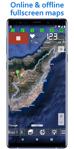
🗺️ Maps: More than 40 map types, including Google, Mapbox, HERE, MapTiler, Thunderforest, CycleOSM, and others
📶 Offline maps with terrain
🌧️ Weather radar map, animated
↕️ Strava global heatmap with thousands of tracks from other users
🧭 Guide routes
🔍 Map auto-zoom depending on speed
🔍 Quick zoom buttons
• User interface
📱 Custom layouts
🎨 Custom colors and fonts
🎨 Light/Dark visual theme
⛵ Screen stabilization: Screen is stabilized by softening small device movements
🗣️ Speech
🎵 Media controls
📈 Live 10-minute charts
👋 Waving mode: Dim and app-lock the screen by waving your hand
👝 Pocket mode: Keeps the screen off while in your pocket
💤 Screensaver with adjustable timeout and dim strength
🎨 Track color by parameter (altitude, speed, etc.)
🖼️ Screenshot: Share the current app screen
🔔 Automatic or manual bell sounds
📣 Automatic or manual moving sounds (AVAS, Acoustic Vehicle Alerting System)
🔦 Flashlight with automatic blinking
🌡️ Derived temperature sensor
ℹ️ More info
The application is built from around 350'000 lines of original source code. That's about 10 times more lines than the famous three-volume fantasy novel.
